Gold Mountain Fire Reaches 37,734 Acres as Crews Build Defensive Lines Near Ouray
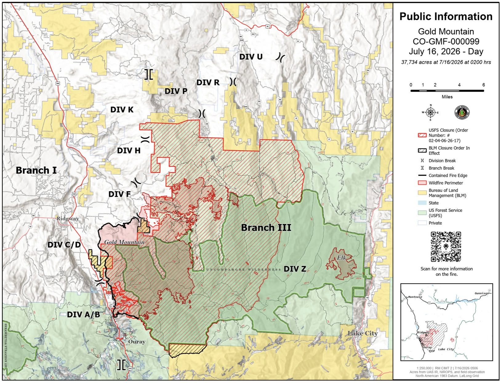
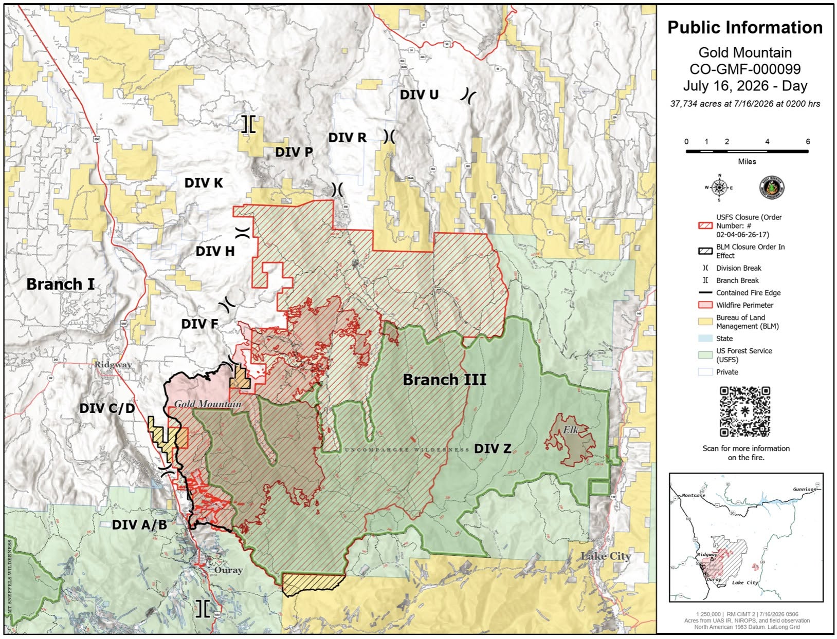
Description: The Gold Mountain Fire is 11% contained at 37,734 acres on July 16. Crews are building indirect firelines, patrolling Highway 550 and protecting nearby communities...
Published: 07/16/2026
Byline: SECO News

Gold Mountain Fire Update - July 16, 2026
Rocky Mountain Complex Incident Management Team 2
Incident Commander Rodney Redinger
Size: 37,734 acres | Containment: 11% | Cause: Undetermined | Start Date: June 27, 2026 @ 5:33p.m.
Location: Approx. 2 miles NE of Ouray, CO | Total Personnel: 929
Safety Message: The Temporary Flight Restriction (TFR) area was expanded and it also abuts to the TFR for the Elk Fire to the east. Firefighters depend on aerial resources to drop water, haul equipment and supplies, recon the fire area, and in the event of medical emergencies, extract injured firefighters. The TFRs are in place to ensure the safety of the pilots and the firefighters on the ground. Incursions of the TFRs by drones will result in the immediate grounding of all aircraft. Think first before you fly and keep our firefighters safe.
Current Conditions: Most of the fire activity is occurring in the Middle and West Forks of the Cimarron and south to Turret Ridge. Northeast winds from afternoon thunderstorm activity continued to push the fire into already blackened areas. As a result, most of the fire activity occurred in the interior with some single and group tree torching.
The plan and implementation of building indirect firelines to the north and northeast of the fire’s progression was initiated by the previous incident management team assigned to the Gold Mountain Fire. When RM CIMT 2 took command of the fire, the work continued providing a seamless transition in accomplishing objectives of the strategic actions put in place.
In the lower end of the fire north of Ouray, a few staffed engines will remain to patrol and mop up hot spots as needed around structures along the Hwy 550 corridor. Crews will continue chipping debris, mop up, and patrol of the lines toward Nate Creek.
Firefighters are working on constructing indirect firelines, utilizing dozers and connecting with road systems north from Nate Creek, moving west of Coons Reservoir and above BLM lands. They will link with the Cimarron Mountain Rd, then south by the Cimarron, Fish Creek, and Silver Jack Reservoirs. Multiple checklines, designed to slow the advance of fire, have been constructed off of the primary indirect lines around communities to protect structures and other values at risk throughout these areas.
Weather and Fire Behavior: Thunderstorm activity is slowly getting stronger with increased lightning as the week progresses. Moisture has been and will likely continue to be minimal. Temperatures are reduced with the cloud cover, and relative humidities continue to rise.
Air Quality – Scan the QR code at the top for the link to the current Gold Mountain Fire Smoke Outlook report.
Temporary Flight Restrictions (TFR): To get the exact restricted airspace over the Gold Mountain Fire, go to www.tfr.faa.gov. The NOTAM Number is FDC 6/5451.
#goldmountainfire Information
Phone: (970) 355-3286 (8:00 a.m. to 8:00 p.m.)
Email: 2026.goldmountain@firenet.gov
Facebook: Gold Mountain Fire
YouTube: www.youtube.com/@goldmountainfire
Follow SECO News on Facebook.
Subscribe to the SECO News YouTube Channel.
Click to Zoom
.jpg)
Press releases Sponsor




.jpg)


.png)

.png)











.png)