Gold Mountain Fire Grows to 14,960 Acres Near Ouray, Red Flag Warning Continues
Description: July 1, 2026 Gold Mountain Fire Update: The fire near Ouray has grown to 14,960 acres with 0% containment as crews protect homes, Hwy 550, and other values at risk...
Published: 2 hours ago
Byline: SECO News

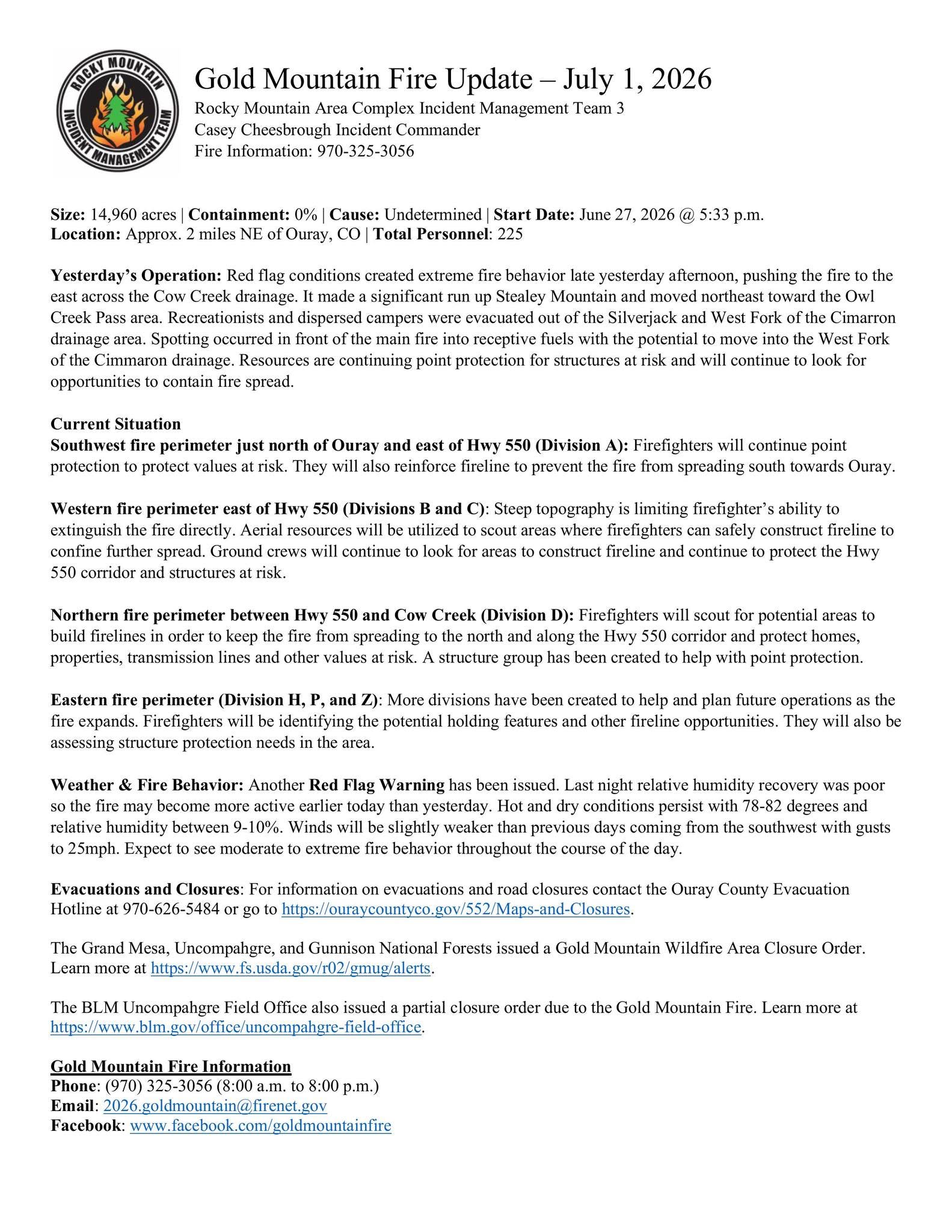
Gold Mountain Fire Update – July 1, 2026
Rocky Mountain Area Complex Incident Management Team 3
Casey Cheesbrough Incident Commander
Fire Information: 970-325-3056
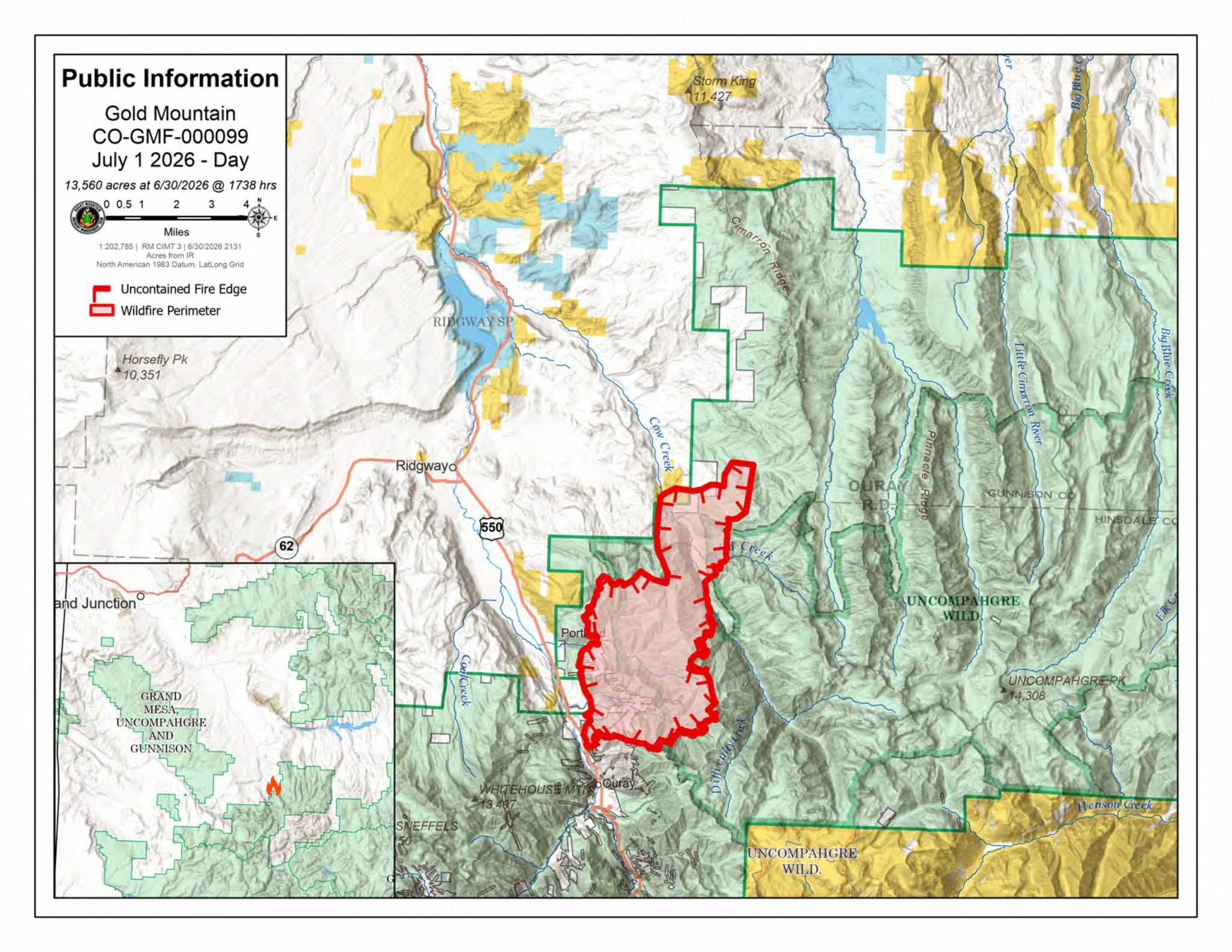
Size: 14,960 acres | Containment: 0% | Cause: Undetermined | Start Date: June 27, 2026 @ 5:33 p.m.
Location: Approx. 2 miles NE of Ouray, CO | Total Personnel: 225
Yesterday’s Operation: Red flag conditions created extreme fire behavior late yesterday afternoon, pushing the fire to the east across the Cow Creek drainage. It made a significant run up Stealey Mountain and moved northeast toward the Owl Creek Pass area. Recreationists and dispersed campers were evacuated out of the Silverjack and West Fork of the Cimarron drainage area. Spotting occurred in front of the main fire into receptive fuels with the potential to move into the West Fork of the Cimmaron drainage. Resources are continuing point protection for structures at risk and will continue to look for opportunities to contain fire spread.
Current Situation
Southwest fire perimeter just north of Ouray and east of Hwy 550 (Division A): Firefighters will continue point protection to protect values at risk. They will also reinforce fireline to prevent the fire from spreading south towards Ouray.
Western fire perimeter east of Hwy 550 (Divisions B and C): Steep topography is limiting firefighter’s ability to extinguish the fire directly. Aerial resources will be utilized to scout areas where firefighters can safely construct fireline to confine further spread. Ground crews will continue to look for areas to construct fireline and continue to protect the Hwy 550 corridor and structures at risk.
Northern fire perimeter between Hwy 550 and Cow Creek (Division D): Firefighters will scout for potential areas to build firelines in order to keep the fire from spreading to the north and along the Hwy 550 corridor and protect homes, properties, transmission lines and other values at risk. A structure group has been created to help with point protection.
Eastern fire perimeter (Division H, P, and Z): More divisions have been created to help and plan future operations as the fire expands. Firefighters will be identifying the potential holding features and other fireline opportunities. They will also be assessing structure protection needs in the area.
Weather & Fire Behavior: Another Red Flag Warning has been issued. Last night relative humidity recovery was poor so the fire may become more active earlier today than yesterday. Hot and dry conditions persist with 78-82 degrees and relative humidity between 9-10%. Winds will be slightly weaker than previous days coming from the southwest with gusts to 25mph. Expect to see moderate to extreme fire behavior throughout the course of the day.
Evacuations and Closures: For information on evacuations and road closures contact the Ouray County Evacuation Hotline at 970-626-5484 or go to https://ouraycountyco.gov/552/Maps-and-Closures.
The Grand Mesa, Uncompahgre, and Gunnison National Forests issued a Gold Mountain Wildfire Area Closure Order. Learn more at https://www.fs.usda.gov/r02/gmug/alerts.
The BLM Uncompahgre Field Office also issued a partial closure order due to the Gold Mountain Fire. Learn more at https://www.blm.gov/office/uncompahgre-field-office.
Gold Mountain Fire Information
Phone: (970) 325-3056 (8:00 a.m. to 8:00 p.m.)
Email: 2026.goldmountain@firenet.gov
Facebook: www.facebook.com/goldmountainfire
Ouray County Emergency Management
Gunnison County Emergency Management
Hinsdale County Office of Emergency Management
San Miguel County Sheriff - Colorado
Montrose County Sheriff's Office
Delta County Sheriff's Office
U.S. Forest Service-Grand Mesa, Uncompahgre & Gunnison National Forests
Follow SECO News on Facebook.
Subscribe to the SECO News YouTube Channel.
Click to Zoom

Press releases Sponsor


.png)


.png)


.png)


.png)